CENTRAL

LIMA
In the north is the city of Caral, the oldest civilization of America, and to the south is the Archaeological Complex of Pachacamac. Lima's history predates the colonial presence in the country. The establishment of the viceroyalty transformed the city into the main political and administrative center of South America. During this period, significant churches, monasteries, mansions and balconies were built. he arrival of modernity didn’t transform the historic center, which is recognized as a World Heritage Site.
Museums with great works of art, archaeological sites, beaches, the boardwalk, valleys, natural reserves, the nightlife, the thrill of adventure sports, and the exquisite cuisine gives Peru’s capital an authentic personality and makes tourism in Lima a unique experience in the country.
Location: On the west central coast of Peru, on the shores of the Pacific Ocean.
Extension: Metropolitan Lima: 2,817 km2.
WHAT TO WEAR...
Lima’s climate is dry and warm in the areas near the coast. There is high humidity and a lack of rain throughout the year. In areas more than 2,500 metres above sea level, the temperature drops and the climate is cold and wet.
Arid and semi-warm
Maximum temperature 27°C 81°F
Minimum temperature 14°C 57°F
WHAT TO EAT...
Cebiche
Cau-cau
Causa rellena
Escabeche (pickle)
Anticuchos
Choros a la chalaca
Carapulcra
Lomo saltado (Fried loin)
Tacu-tacu
WHERE TO GO...
IN THE CITY:
Lima Plaza Mayor (Main Square)
Lima Cathedral
Government Palace
San Francisco Church and Convent
Gastronomy House
OUTSIDE THE CITY:
Mamacona Estate (Lurín)
Pachacámac Town (Lurín)
Pachacámac Archaeological Complex (Lurín)
Lunahuaná (Cañete)
Caral (Barranca)
PASCO
A land of marked contrasts, where the mountains and jungle form a chain of cold peaks and lush vegetation. Huayllay’s “Forest of Stones” consists of unusual rock formations and countless lagoons. This region is inhabited by native peoples and includes picturesque towns such as Huancabamba, Oxapampa, Pozuzo and Villa Rica, which are inhabited by Austrian-German settlers who have combined their culture with local customs. It has very diverse flora and fauna, and scenery dotted with numerous waterfalls.
Pasco marks the entrance to the exuberant central jungle region.
Location: Located in the center of Peru, to the east of the Cordillera Occidental (West Andes). Most of the region consists of high jungle ecosystems, but its capital and other major cities are located in Andean areas.
Size: 25,320 km2 (9,776 sq.miles).
WHAT TO WEAR...
The climate of the towns and villages in the Daniel Alcides Carrión and Cerro de Pasco provinces is cold and wet, with medium humidity. On the other hand, the towns and villages of Pozuzo, Villa Rica and Huancabamba have a temperate and very wet climate, while Oxapampa’s climate is hot and extremely wet, with high humidity.
Temperate
Maximum temperature 12°C 54°F
Minimum temperature -2°C 28°F
WHERE TO GO...
IN THE CITY:
No Places Found in City!
OUTSIDE THE CITY:
San Pedro de Ninacaca Church (Pasco)
Inmaculada Concepción de Vicco Church (Pasco)
Punrun Lagoon (Pasco)
Huayllay National Sanctuary (Pasco)
La Calera Hot Springs (Pasco)
WHAT TO EAT...
Jora chicha
Pachamanca
Picante de cuy (Spicy guinea pig)
CALLAO
This is the vital route for trade both into and out of Peru. It has mansions with pretty balconies, museums, churches and the fortress of King Felipe, which survived wars and pirate attacks. As well as tradition, in Callao you can enjoy nature on the islands of Palomino and San Lorenzo, in the Humedales de Ventanilla (wetlands) or on the pebble beaches.
It is just a couple of minutes away from Lima.
Location: Central west coast of Peru. 12 km (7 miles) from downtown Lima.
Size: 158 Km2 (61 sq. miles)
WHAT TO WEAR...
Hot in the summer, mild in the autumn and spring, and cold in winter with some drizzle. High humidity throughout the year.
Humid and cloudy with a sunny summer.
Maximum temperature 30°C 86°F
Minimum temperature 14°C 57°F
WHERE TO GO...
IN THE CITY:
Real Felipe Fortress
Mother Church, or Callao Cathedral
Francisco Bolognesi Plaza
Independence Plaza
La Merced Tower Plaza
OUTSIDE THE CITY:
Palomino, Cavinzas, San Lorenzo and Frontón islands
Abtao Naval Submarine Museum
WHAT TO EAT...
Cebiche
Parihuela
Chimbombo sandwich
Leche de tigre (Tiger milk)
Choritos a la chalaca
HUANCAVELICA
Huancavelica proudly boasts many attractions such as archaeological sites, temples and mansions in its urban core. A past surrounded by a pleasant environment of natural, therapeutic hot springs, fertile lands, lakes and snowy mountains: the heart of the Andes, dominated by two great cultures, the Wari and the Chancha. It was later transformed by the Inca into a military center, and later it was turned into a Spanish city to exploit silver and mercury.
Location: Central highlands of Peru, a rugged terrain of valleys, deep gorges, high mountains, winding roads and plateaus.
Size: 22,131 Km2 (8,545 sq. miles)
WHAT TO WEAR...
Huancavelica City, the capital of the region, has a cold and wet climate. The rainy season begins in November and ends in April.
Cold and rainy.
Maximum temperature 16°C 61°F
Minimum temperature 2°C 36°F
WHERE TO GO...
IN THE CITY:
Plaza de Armas
San Antonio Cathedral Church
Temple and Convent of San Francisco
Temple of Santo Domingo
Temple of San Juan de Dios
OUTSIDE THE CITY:
Uchkus Inkañan Archaeological Complex (Huancavelica)
Chonta peak (Huancavelica)
Pultocc Lagoon (Huancavelica)
Choclococha Lagoon (Huancavelica)
Izcuchaca district (Huancavelica)
WHAT TO EAT...
Breaded alpaca meat
Pachamanca
Bread
UCAYALI
The first people to live in this area, which extends along the length of the Ucayali river and its tributaries, were the Pano, in approximately 2,000 BC. Many indigenous communities live in the Amazon and do not renounce their ethnic customs and traditions, but instead share their invaluable culture with the world. With scenery bathed in powerful rivers, where the waterfalls are enormous veils that cover the mountain and transform into calm lakes, the diversity of flora and fauna in Ucayali continues to astonish scientists.
Location: Peru's central jungle (the Amazon) hosting three natural levels: low jungle, high jungle and jungle fringe.
Size: 102,411 km2.
WHAT TO WEAR...
Rainy and hot. It rains in three of the four seasons (autumn, spring and summer).
Rainy and hot
Maximum temperature 34°C 93°F
Minimum temperature 19°C 66°F
WHAT TO EAT...
Masato
Inchicapi
Tacacho con cecina (Tacacho with jerky)
Patarashca
Juane
WHERE TO GO...
IN THE CITY:
Pucallpa Plaza de Armas
Pucallpa Cathedral
Plaza del Reloj Público (Clock Tower Plaza)
Pucallpa National Park and Regional Museum
Lake Yarinacocha
OUTSIDE THE CITY:
Cashibo-Cocha Lagoon (Coronel Portillo)
Imiría Lake (Coronel Portillo)
Pimienta Cocha and La Juventud Lagoons (Coronel Portillo)
Aguaytía (Padre Abad)
Boquerón del Padre Abad (Padre Abad)
JUNIN
Highlands and jungle. Waterfalls and fertile valleys. Pristine landscapes. Handicrafts and folklore. Junín is charming like love at first sight. Villages with deep religious traditions, such as Tarma. A National Reserve with birds and mammals of the Andes. A handicraft route where you can see the production of fine weaving and metalwork in gold and silver.
And as a backdrop, a dark green carpet of forests in Satipo and Chanchamayo, with botanical gardens and accommodation in native communities.
Location: Central mountains and forest.
Size: 44,410 km2 (17,147 sq. miles).
WHAT TO WEAR...
Huancayo City has a rainy and cold climate. The rainy season lasts from October to April.
Cold and rainy.
Maximum temperature 21°C 70°F
Minimum temperature 2°C 36°F
The Chanchamayo and Satipo valleys (low jungle) have a tropical, warm and wet climate.
Cold and rainy.
Maximum temperature 32°C 90°F
Minimum temperature 14°C 57°F
WHAT TO EAT...
Pachamanca
Spit-roasted lamb
WHERE TO GO...
IN THE CITY:
Constitution Plaza
Huancayo Cathedral
La Merced Chapel
Huanca Identity Park
Cerrito de La Libertad (Freedom Hill)
OUTSIDE THE CITY:
Huaytapallana Peak (Huancayo)
Wariwillka Sanctuary (Huancayo)
Ingenio
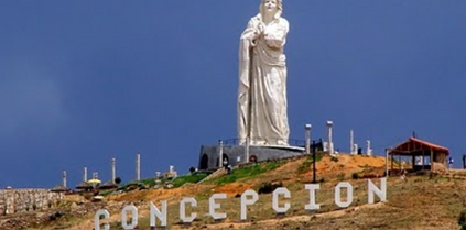
Plaza de Armas (Concepción)
Ocopa Convent (Concepción)
HUANUCO
Huánuco was a colonial center where temples, haciendas and mansions were built in an area that, for centuries, had been populated by the Lauricocha and other cultures, who left traces of their presence in the Kotosh
“Templo de la Manos Cruzadas “ (Temple of the Crossed Hands). This beautiful area has forests full of sought-after fruits like coffee and cocoa, along with a variety of protected flora and fauna in the Tino María national park. High mountains, hot springs, caves, lagoons, and a remarkable rock formation called Sleeping Beauty, make Huánuco the soul of the Andes, dressed in jungle.
Location: Highlands and central jungle of Peru, the Andean region is marked by the presence of the Huayhuash Range, Raura, and the jungle stretching across the eastern flank of the Andes.
Size: 37,722 Km2 (61 sq. miles)
WHAT TO WEAR...
Temperate and dry, with a rainy season between December and April.
Temperate and dry
Maximum temperature 28°C 82°F
Minimum temperature 12°C 54°F
WHERE TO GO...
IN THE CITY:
Plaza de Armas de Huánuco - Street intersections
Cathedral of the city of Huánuco
San Francisco Church
Kotosh or Temple of the Crossed Hands
Calicanto Bridge
OUTSIDE THE CITY:
Shismay Estate (Huánuco)
Garu Archaeological Complex (Yarowilca)
Tomayquichua (Ambo)
La Perricholi House (Ambo)
Huánuco Pampa Archaeological Complex (Dos de Mayo)
WHAT TO EAT...
Chicha de jora
Picante de cuy (Spicy guinea pig stew)
Juane
Sugar cane |guarapo|
Pachamanca
Inchicapi
Masato
Tacacho con cecina (Tacacho with jerky)
Chifles
ANCASH
Among its wide variety of attractions you can find snow-capped mountains, lakes, valleys, beaches and unique flora and fauna. You can also appreciate the buildings of ancient, pre-Incan civilizations, and enjoy festivals that bring together tradition and the present-day way of life of its new inhabitants. Áncash has strikingly varied scenery, with its high peaks, like the snow-capped mountain Huascarán (6,768 meters above sea level), hundreds of lakes, picturesque valleys, like the Callejón de Huaylas, and trails bordered by eucalyptus trees and retama flowers that cross over the Andes to the archaeological site of Chavín de Huántar.
This is just a small taste of the cultural richness of Áncash – a destination that promises adrenaline-filled experiences.
Location: Northwest coast and highlands of Peru. Very diverse geography, with beaches and very steep, snowy mountains in the Andes Mountain Range, the highest in Peru (Huascarán, 6,768 masl - 22,205 fasl).
Size: 35,459 Km2 (15,154 sq. miles)
WHAT TO WEAR...
The city of Huaraz has a dry and temperate climate. The rainy season lasts from November to March.
Dry and temperate.
Maximum temperature 23°C 73°F
Minimum temperature 4°C 39°F
WHAT TO EAT...
Picante de cuy (Spicy guinea pig)
Pachamanca
Casmeño duck ceviche
Tamales
Chocho bean ceviche (Tarwi)
Humitas
WHERE TO GO...


